Heatmap Update
I have previously talked about my heatmap goals. With 2021 behind us, I felt like giving an update and writing out what I see myself focusing on in 2022.
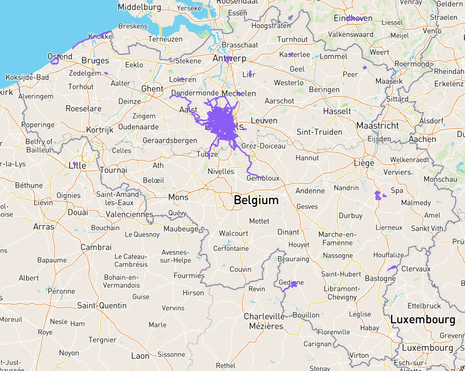
Brussels Update
Situation at the end of the year. Things slightly changed again by the time I got this post out.
| Municipality | Done | Inc | Total streets |
|---|---|---|---|
| Anderlecht | 56 % | +41 % | 510 |
| Brussels City | 94 % | +16 % | 1194 |
| Elsene | 100 % | +84 % | 341 |
| Etterbeek | 100 % | +75 % | 199 |
| Evere | 100 % | +84 % | 176 |
| Ganshoren | 100 % | – | 122 |
| Jette | 100 % | – | 212 |
| Koekelberg | 100 % | – | 78 |
| Molenbeek | 100 % | +1 % | 294 |
| Oudergem | 60 % | +54 % | 260 |
| Schaarbeek | 74 % | +48 % | 369 |
| St-Agatha-Berchem | 100 % | – | 133 |
| St-Gillis | 100 % | +91 % | 159 |
| St-Joost | 100 % | +5 % | 117 |
| St-Lambrechts-Woluwe | 31 % | +14 % | 302 |
| St-Pieters-Woluwe | 25 % | +19 % | 325 |
| Ukkel | 64 % | +56 % | 421 |
| Vorst | 44 % | +42 % | 201 |
| Watermaal-Bosvoorde | 98 % | +87 % | 259 |
| Total | 76 % | +38 % | 4986 |
The above table compares numbers to the previous blog post back in May. In terms of the ranking on CityStrides, I went up to the second spot in Brussels. First place was around 84% last I checked. I am still behind, but slowly closing in.
I used good weather days to get parts of the far side of Brussels done. Calm bike ride over, do a run, bike back. It is quite nice when not too cold and with some sun out. Sadly that is not possible on workdays, it just takes too much time. Big focus of that approach was Ukkel.
In October I briefly started going to the office again. I switched all my work day running to be lunch time runs in that area. This enabled me to focus on Etterbeek, Elsene, and Watermaal-Bosvoorde. Alas, work from home laws came back into effect following yet another COVID-19 surge and that approach was largely put back on hold.
I have made a video showing the progress on Brussels streets in 2021. The first view is prior to any 2021 running, every change is another month of progress.
I described elsewhere how to make such a video.
Cross Belgium
From the previous post:
What will probably end up happening with this goal is me doing a little bit here and there as I find motivation to do anything or happen to be in certain areas.
That indeed ended up happening, meaning very little progress was made since then. Specifically, I only ‘worked’ on this one twice. One time, I felt motivated to take the train out to Wetteren and ran from there back to my tendril in Aalst. That is about halfway to Gent, so now I should be able to make that connection more easily. The other time, I happened to be in Knokke for a coastal weekend with a friend. I took the opportunity to run to the Belgian-Dutch border and a bit in the Knokke area. Not a lot of progress, but touching the border there already feels like a nice achievement and will look nice later on.
Run the Coast
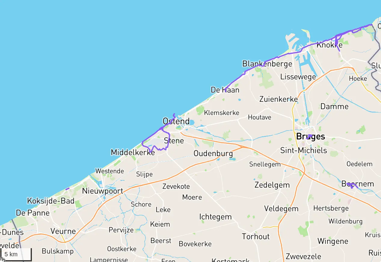
This plan had already formed before the trip to Knokke mentioned in the previous section, but that Knokke trip solidified it: I want to run across the entire Belgian coast. If you are unfamiliar with the Belgian coast, that might sound like a lofty goal. Trust me though, it is not. It is only around 70-75 km of running total and pretty well serviced by public transport. It is really just a matter of heading over to that side of Belgium.
Thus, when I was in Knokke, after making the Belgian-Dutch border connection, I spent another morning taking the tram out so I could run back to where we were staying. With barely any running, I now already have a little more than a third of the coast complete.
The Blob
Not much conscious effort has been put into this. I largely just run and try to get some new streets whenever possible. That said, sometimes I do go out of my way for a “folieke” just because it looks nice on the map or because I am in a mood.
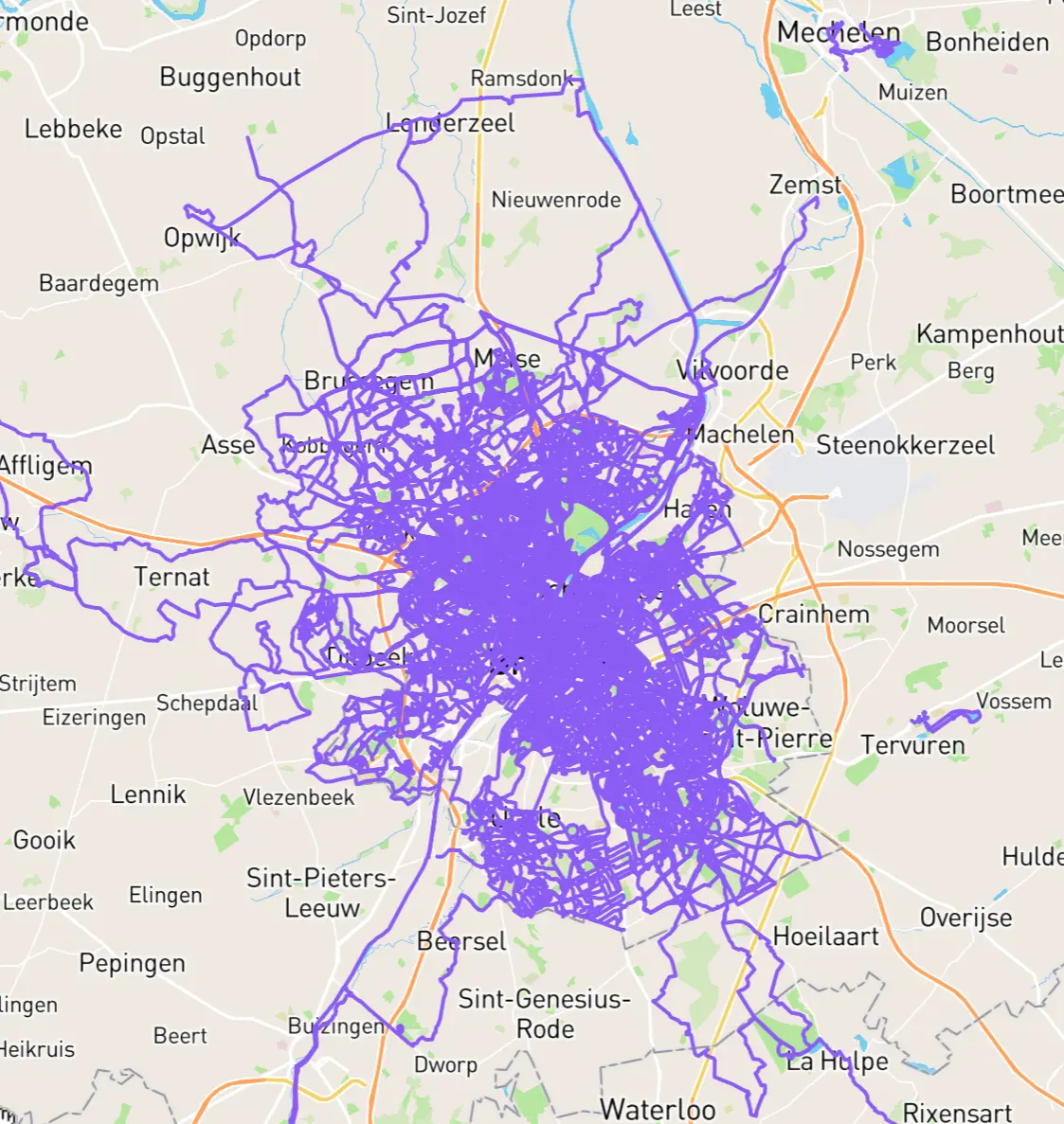
During the year I got some heatmapping done in Mechelen and Tervuren. They are both a bit out of the way, but it is tempting to connect them to the blob. I would also like to connect Opwijk to Affligem (in the north-west) and Dworp to Waterloo (in the south). Beyond that, nothing particular comes to mind.
Pennsylvania
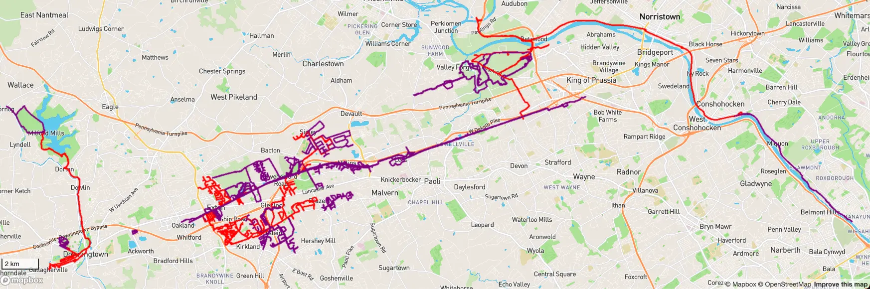
The USA border had long been closed to me because of COVID-19 regulations. With the recent reopening I was finally allowed back in, and I ended up heading once more into the Philadelphia suburbs to visit the girlfriend’s family. Back in 2015 we had done some minor heatmapping effort, but that had quickly sizzled back out (just like most my heatmapping had) and since then most of the running had been done along the Chester Valley Trail or in the Valley Forge area. Always the same few routes.
This time around, I arrived with a newfound motivation. Having taken it so seriously in Brussels, it was easy to continue the habit there. Easy to motivate myself anyway. Suburbia USA has one big problem: they seem to hate pedestrians with a vengeance. You have your own little neighbourhood (a dead end of a few streets) and to get to another one you have to run on deathly roads with high speed limits, a car lane each way, and everyone else can get fucked. Getting anywhere without a car can get rather dangerous. The safest way to get streets done is to drive to a neighbourhood, park there, run the neighbourhood, and go to another one. Not very pleasant.
This is a bit of a drag, especially with our car situation while there. Instead, I decided to not focus too much on the actual street count and tried to connect up the different bits of heatmap I had. Sound familiar? We’re creating another blob, ladies and gentlemen! One downside: them dangerous streets. I had made up my mind though, I had packed my fluorescent running vest before heading state side and I figured I would give it an honest try.
It actually went better than expected. I think I was helped by doing it around Christmas-New Year. Perhaps also due to more people working from home or picking the right hours (i.e., not during rush hour or lunch time). Whatever the reason, it was not as busy as I remembered it being the past years. Most streets I could handle fine with the tiny bit of shoulder that was given to me and the patches of grass I could hop onto if necessary. Several places were not as forgiving, but I did my best to tackle those as defensively as possible: always wait for the cars to do their things, try to wait it out so you do not see a car coming in the distance, run the dangerous part with a certain urgency (no all out sprint to ensure full focus). For some, I also managed to convince the girlfriend to drop me off in one spot, have her drive to a place where walking is nice, and just have her go for a walk there while waiting for me to run over. That helped a lot, good thing we are all so used to having to drive to get any safe running done in this area.
When I was in a situation where I could not connect any parts on that day, I instead decided to risk other brief moments of danger to reach other nearby neighbourhoods and do some good ol’ street hunting.
Plans For 2022
- Brussels. Finish it up. The order of the communes does not matter much, but I will probably try ticking them off one-by-one to have small achievements along the way.
- Brussels, bis. Do an extra sweep for streets marked complete on CS but not actually complete. Think streets where you have run by both ends, but not through it. This can often mark it as complete in CS, due to CS only taking nodes of a way into account. I.e., the node on either end.
- Cross Belgium. This will continue being “when inspired”. Travelwise it is a bit of a drag, especially the (longer) south side of Belgium.
- Run the Coast. I will not go out of my way to do any of this. That said, in the off case that we decide to head to the coast for a weekend, I will suggest going to an area I have not yet completed. Might as well.
- Blob. Not a specific focus, but I am sure I will sometimes just feel like biking to the edges and do a random long run. Some desire to connect to Mechelen and to Tervuren, as well as making Opwijk-Affligem and Dworp-Waterloo connections.
- Pennsylvania. We should be able to start heading over more regularly again, so I expect I will continue connecting parts and expanding the blob there. Mainly I want to connect my main blob to the Downingtown-Marsh Creek connection I have to the west of it. Due to dangerous roads I will probably have to do a big detour to achieve this, but I have a bit of a plan in my mind for that. Another nice to have would be expanding the east side further east to reach the center of Philadelphia. It is about 9 km to the Art Museum (Rocky steps), 11 km to the city hall, and 13 km to the Liberty Bell. Sadly I never tracked any walks or runs there in the past, so the entire area still looks pristine. Beyond those two ideas, everything will always be heavily in function of time and car situation so I hesitate to state any further goals.
- Other. Brussels might not always be possible or what I am in the mood for on a given day. Perhaps I can work on one of the Flemish villages outside the Brussels border? Not sure yet which one though. Might feel like splitting this up into two approaches. (1) a closer side where I could still run to on long runs, or take the bus to and run back home (2) a further side that requires biking, or similar, over, running there, and biking back home.