Heatmap Goals
Maps are fun. Running is fun. Why not combine the two? It all started years and years ago with wanting to visualise all my runs together on one single map. Once you have that, it is a small step to wanting to make the visual bigger, better, all encompassing. That is what this post is about.
(I do not particularly care about seeing where I pass by more often, so “heatmap” is a bit of a misnomer, but I never did find a better name for it.)
The Software: CityStrides
So there are definitely a few tools out there that let you generate such a map, but my favourite by far is CityStrides. It does not just show such a map (it calls it “the lifemap”), it also keeps track of which streets you have done in a particular city. Now you have another number to aim to increase! On top of that, you can also see how others in your city(ies) are doing so if you like competition that might be another motivator.
As an example, I have currently passed by 1873 of the 4930 streets in Brussels. That is about 38% completed and puts me in fourth position. Preceding me are three people with 80%, 55%, and 45%. Aiming for the top three could be a nice intermediate goal there.
There is also a recently introduced global ranking and CityStrides also keeps track of the number of streets, cities, regions, and countries you have run through in your life. Numbers, numbers, numbers!
Goals
I would say I have three goals when it comes to this heatmap. Now do not get me wrong, they all take a backseat in my goal to get faster. They are however a nice distraction from always running the same few routes. I will list these three goals here, ranked from actionable to vague.
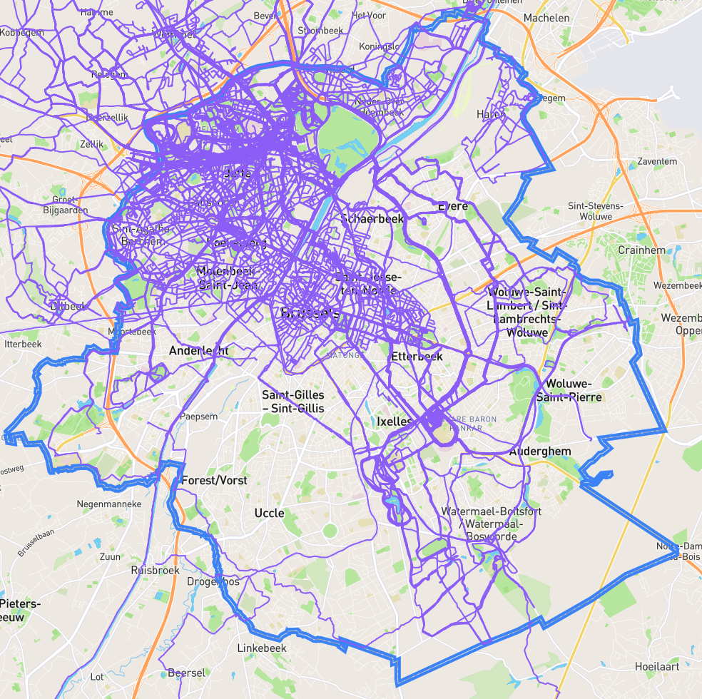
Brussels
Completing Brussels is definitely a long term goal, I am not even halfway there after all. It is however the easiest one to work on. I live in Brussels, so new areas are relatively easy to get to. There is a nice street counter on CityStrides that I can keep on increasing. Brussels is also split into 19 parts that I can aim for one at a time, making the whole goal easier to split up in more manageable parts.
Whenever I have the time, I try to map out a route passing new streets in Brussels. If I really have the time, that involves first biking over to the relevant area. The biking is becoming increasingly necessary as I completed most streets in my direct vicinity.
Here is an overview of how Brussels is coming along. Still a long way to go, clearly, but I am not in a particular hurry.
| Municipality | Done | Total streets |
|---|---|---|
| Anderlecht | 15 % | 513 |
| Brussels City | 78 % | 1160 |
| Elsene | 16 % | 341 |
| Etterbeek | 25 % | 197 |
| Evere | 16 % | 178 |
| Ganshoren | 100 % | 124 |
| Jette | 100 % | 211 |
| Koekelberg | 100 % | 77 |
| Molenbeek | 99 % | 291 |
| Oudergem | 6 % | 258 |
| Schaarbeek | 26 % | 367 |
| St-Agatha-Berchem | 100 % | 133 |
| St-Gillis | 9 % | 159 |
| St-Joost | 95 % | 116 |
| St-Lambrechts-Woluwe | 17 % | 300 |
| St-Pieters-Woluwe | 6 % | 324 |
| Ukkel | 8 % | 417 |
| Vorst | 2 % | 199 |
| Watermaal-Bosvoorde | 11 % | 259 |
| Total | 38 % | 4930 |
Note: Some streets cross multiple municipalities so just summing will not produce the same total as shown in the table.
Cross Belgium
Inspired by seeing someone connect different runs to form a vertical line through Brussels to connect the Belgian-Dutch border to the Belgian-French border, I decided to give myself a harder time. Rather than doing a smart short connection like this other person, I instead figured I should go for just about the longest one you can do. I don’t want to sound dismissive here, it really must have been quite a bit of work. It is just that he already did that, so I want to one up it. Let’s see if I actually manage this one, because it will be a bit of work.
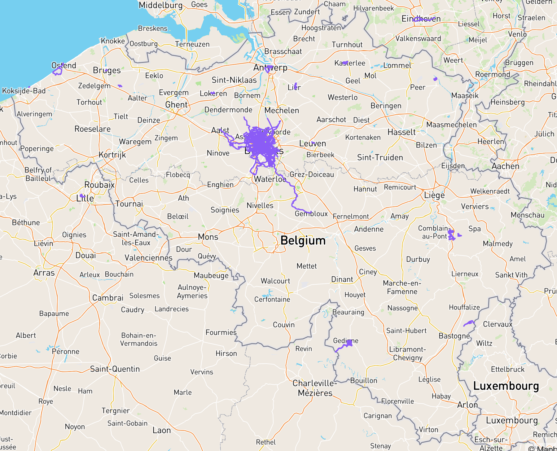
The goal is (1) to go from the coast (either Oostende or Knokke) to my blob in and around Brussels and (2) to connect that south-east tendril further south-east until I reach the three countries point of Belgium, Luxemburg, and France. Still a bit to go. The very shortest route to do the coastal side is another 93 km. The very shortest route on the south east side is 162 km. Of course, both will end up taking more distance than that. I will have to adjust the route in terms of accessibility, both for getting to starting and ending points and for routes I can actually run on.
I lack a car, so that makes this goal a bit more difficult still. Luckily there are train lines I can use. Downside is that it really eats up your day that way. What will probably end up happening with this goal is me doing a little bit here and there as I find motivation to do anything or happen to be in certain areas.
Growing The Blob
The blob is what I affectionately call my running area and all the heatmap connections sprouting from it. Growing the blob is a bit of a vague goal as it is hard to quantify when you have achieved anything there. Are you ever really done? The plan is twofold. On the one hand I want to expand the outer reaches on all sides, covering a larger area. On the other hand I will probably want to ensure it does not look too empty in-between. What is the point of a big spider’s web if the gaps are so big a fly can just zoom through? Stretching the metaphor there, but I hope you get the idea.
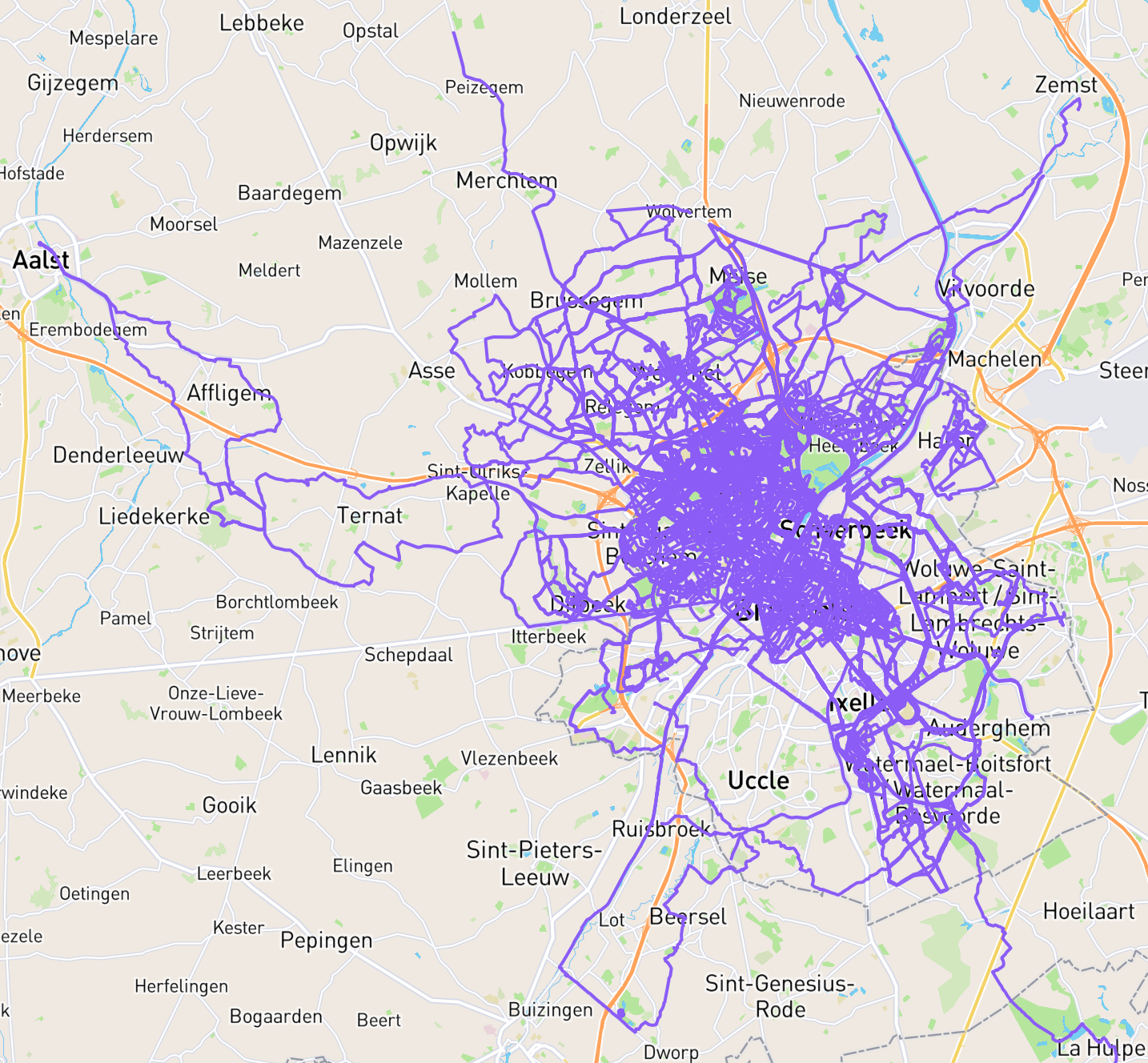
Having a look at the current state of affairs, an option is to fill the emptiness of the south west Schepdaal and Sint-Pieters-Leeuw area, or Opwijk, Meldert, Asse in the north west, or Londerzeel in the north, or bridge out further east. Uccle is also looking pretty empty come to think of it, but the Brussels goal will eventually fix that. The possibilities are endless! In as much as 360 degrees of choice can be considered endless.
This will be mostly long run territory as it is beginning to involve a bit of travel already to get to the frontier. As such it competes with the cross Belgium goal, but has the advantage of being much easier to plan around. I can still just bike to many locations here.
Conclusion
I decided to write down these goals as a bit of accountability to the many many readers of this blog (ahem). Also just will be nice to look back at this in a few months or a year or whenever. A snapshot of my current state of affairs and a look into what is keeping me interested (besides ever trying to get faster).
Who knows, maybe this post will get someone else interested in stupid goals too?