American Long Dumb Shit
In my heatmapping I have the number-goes-up street and hexagon progress to focus on. However, sometimes I just want to do something… sillier. That is where my little adventures come into play. The ideas I lovingly refer to as my Long Dumb Shit.
In Belgium, I would often plan these around train lines. Go to one stop, run to the next. Repeat. Here, I do not have that luxury. Instead, I have to drive somewhere and do a loop (or convince my wife to also waste half her day). Progress is a little slower, but I do not mind.
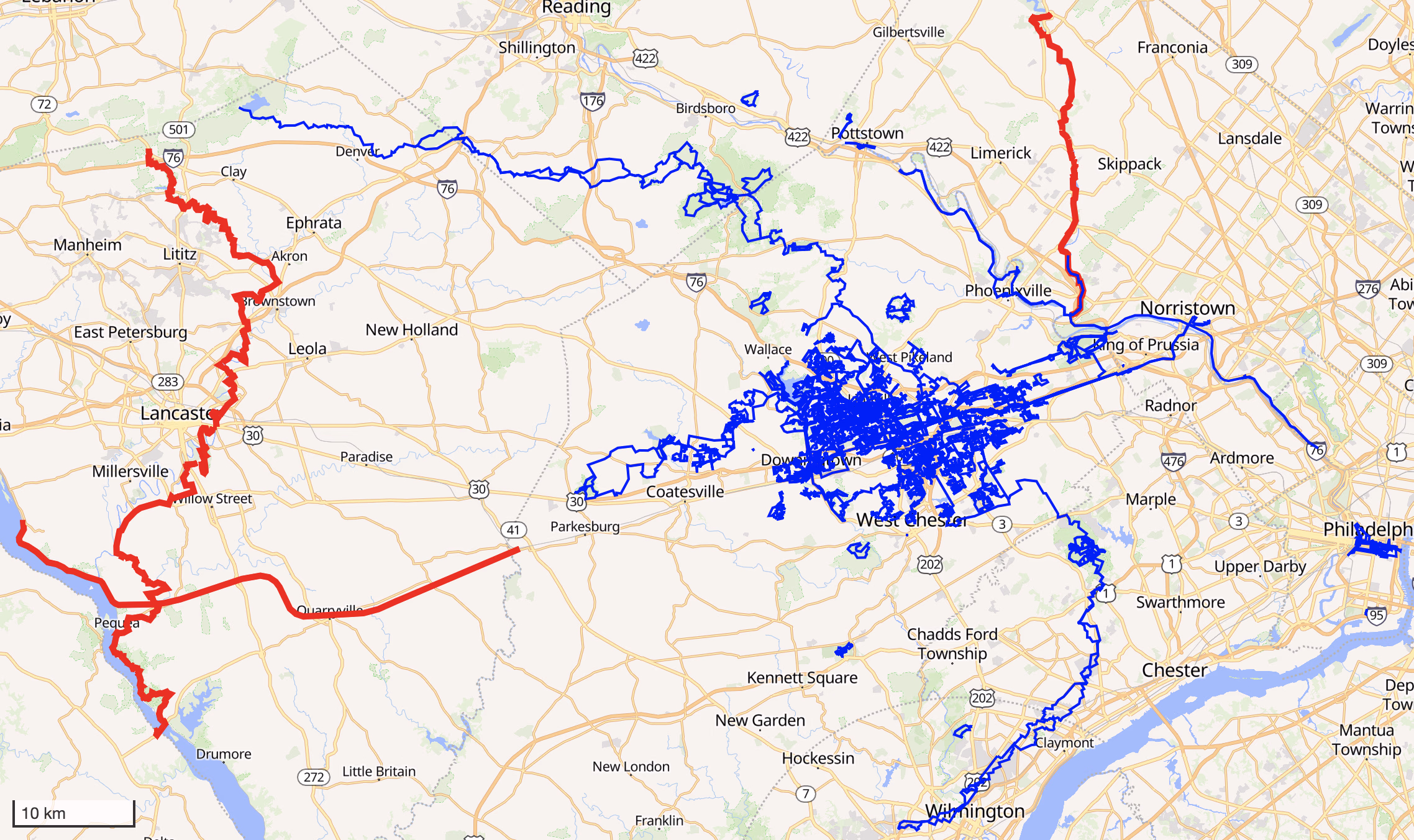
My Blob
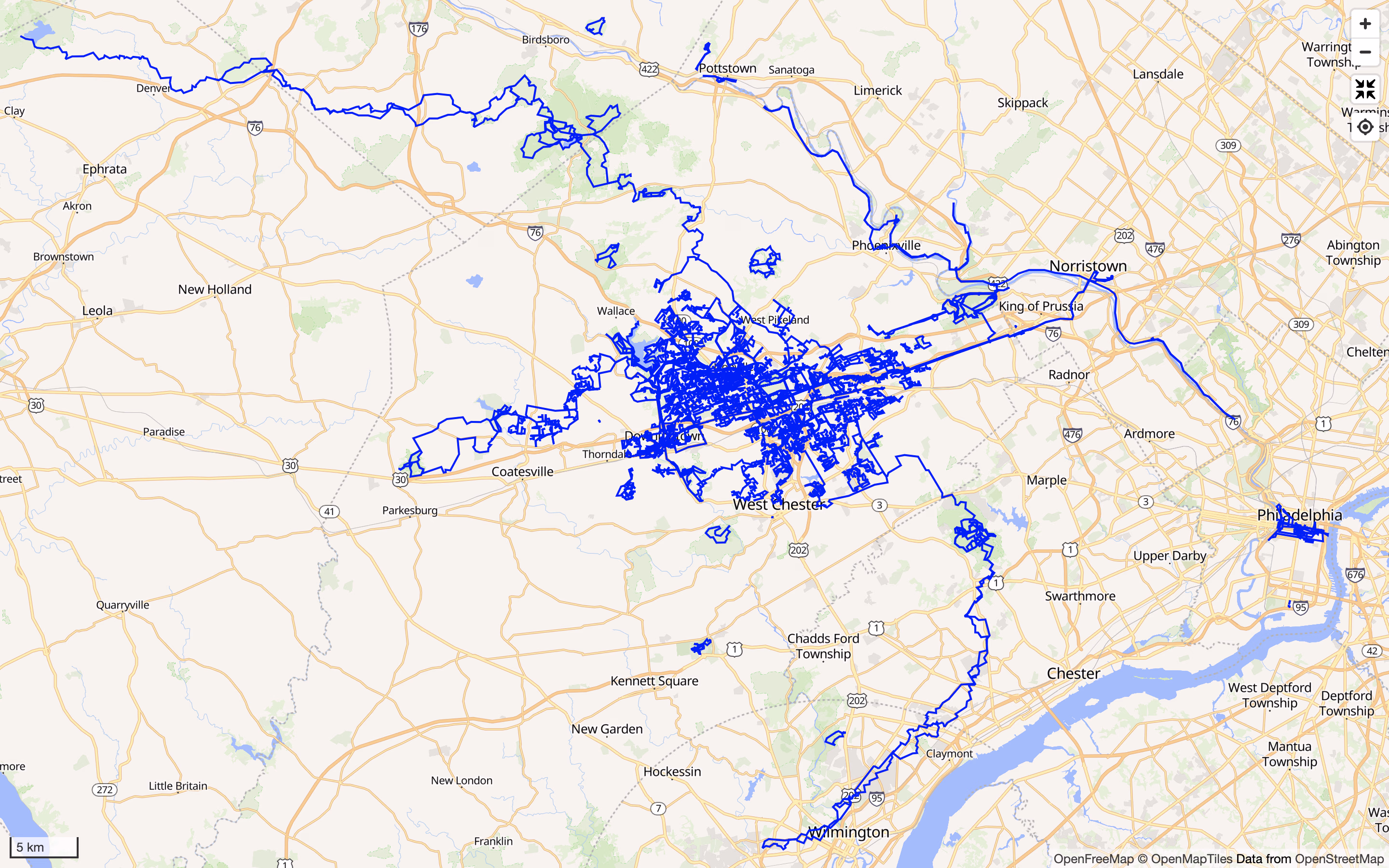
Besides the obvious activity around where we live, I have been creating tendrils vaguely in the cardinal directions. The north and then west one follows the “Horse Shoe Trail”. East is aiming to connect Philadelphia’s center city. South came to be from having to drop my wife off at the Wilmington train station and evolved into another sillier idea. West was more in the process of checking out some parks and nature areas and then wanting to hook them up. For those north, south, and west tendrils I have further ideas. More on them later in this post.
Now, there are still various loose miniblobs. Philadelphia is the most obvious one, but I will get around to that eventually. The connection itself is easy: there is a paved trail along the river. I figure I will be heading in that general direction at some point and try to do it at that point.
The other loose miniblobs are just part of natural progress for now. Some from races, others from checking out a different park or nature reserve, some just from feeling like doing a few neighbourhoods of streets. I am not (yet) as crazy about keeping every new place connected yet as I had become in Belgium. I will connect them, at some point, no rush.
Horse Shoe Trail
The Horse Shoe Trail is a 230 km long route connecting Valley Forge to the Appalachian Trail. I believe I first encountered this trail nearly a decade ago by accident while running in Valley Forge. Specifically up Mount Joy and Mount Misery there. After that, I mostly did not think about it any more for quite some time.
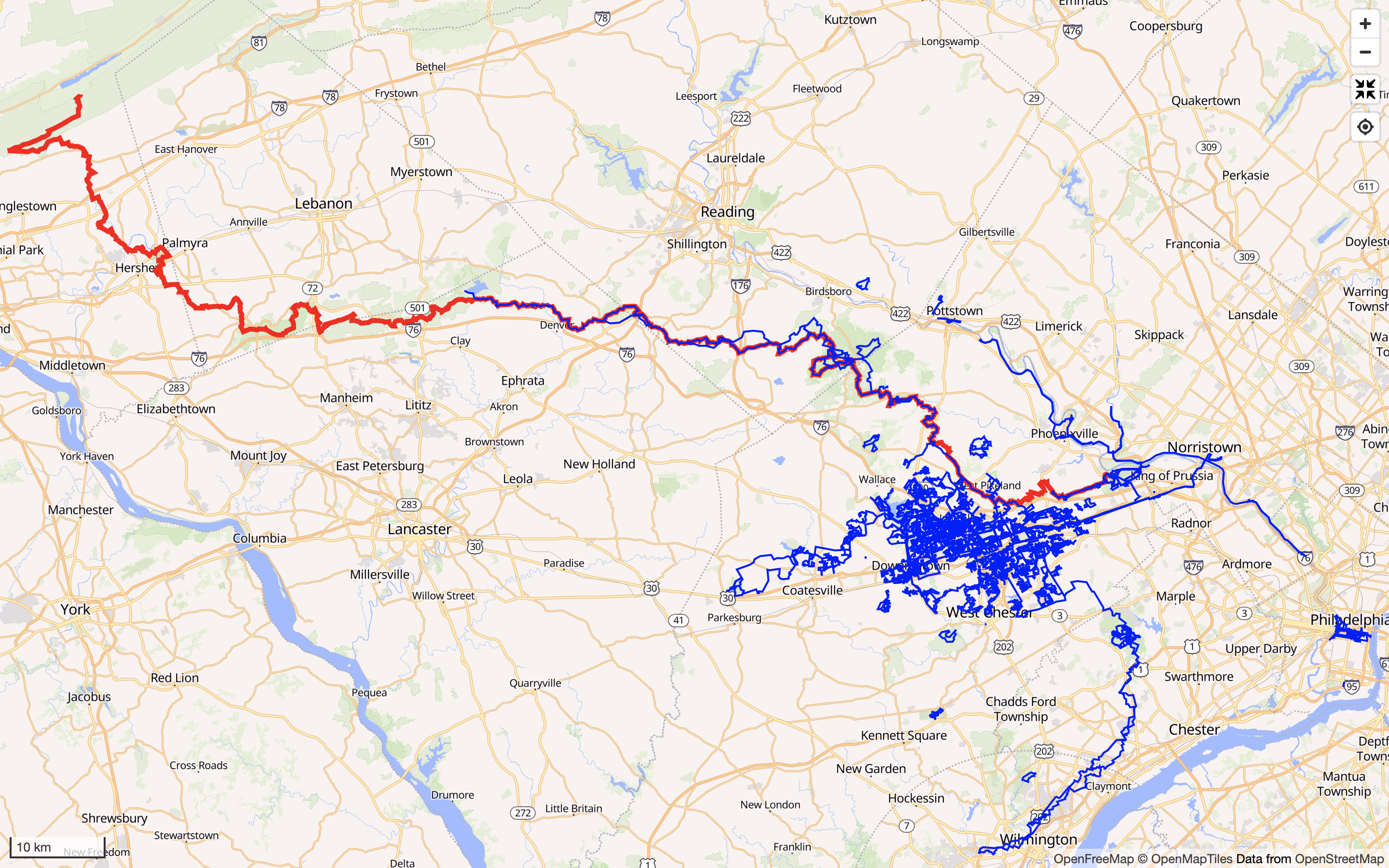
Until the past year that is. I have been slowly chipping away at it when I am in the mood. It was easy enough at the start, all of that is quite nearby, but by now requires a decent bit of driving to reach my next point. I am about halfway through it. As with all things, there is no rush. That said, this is definitely my main Long Dumb Shit goal, time permitting.
One of the weirder challenges with this has been, at times, finding a convenient place to park the car. That is partially on me, I would like to trace the trail if possible. In other words, no matter where I park, I need to still connect to the HST. I cannot just connect my blob in the general direction.
Just as a side note for non-American readers (or non native English speakers, perhaps): while this is called the Horse Shoe Trail, it is not all on trail. The word trail evokes a certain state of the path to me. The people managing this trail do try to get land access for that kind of path, but there are chunks where you are running on streets rather than a beaten path. They also have something called “rail trails” here, which, at least in my area, seems to largely be asphalt bike and walking paths following a former train line. No trails in sight.
Visiting the Capital
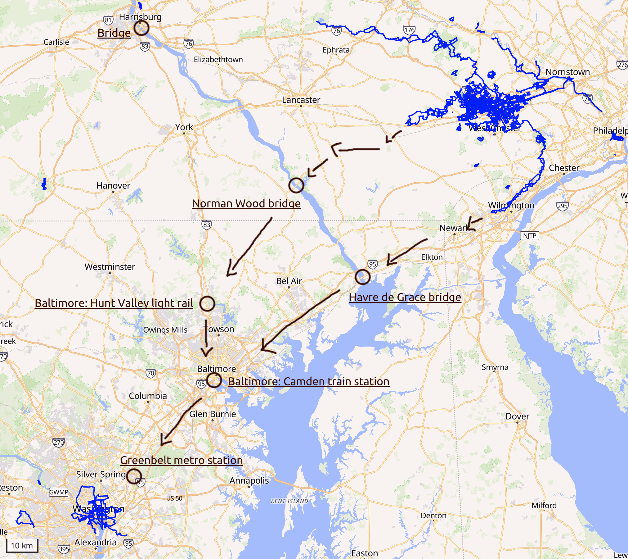
Philadelphia is nestled nicely in the middle between New York City and Washington DC. After connecting so many things in Belgium, it seemed obvious: connect all three together. I do not recall whether I had had this idea before or whether it formed while I was making my Wilmington (Delaware) connection. At the very least, the latter solidified the idea in my head.
This plan will be a total pain to actually get around to. It rather quickly becomes a drive™ and, unlike with the Horse Shoe Trail, I doubt I will be able to find nice nature running on this route.
Practically, I have made the focus of this idea the DC side. My wife sometimes needs to be in DC for work, her brother lives there, there is just more chance of us heading in that direction. I figure I might be able to sometimes squeeze in a run when we do so. Eventually there will be some progress.
The very shortest route (read: definitely not the one I will be able to take) between my blob and the one in DC is 161 km. At a rate of “maybe I will make some progress every 6 months” (at least once the first few 10s of km of that are done) I think this will be a very long term goal indeed. Still, a boy can dream.
The distance is not even the first main hurdle to tackle here. Do you see that big blue river there cutting through? That is the Susquehanna river and I have to cross that. I had a look at the bridges across it and THEY ARE ALL HIGHWAYS. Come on, America, stop hating everyone else. OK, some are “highways”, so more like state routes, but I still could not spot sidewalks or shoulders I would feel safe on. As I get closer, I will have a better look at all the bridges again, but for now I only see three options:
- Cross all the way in the north west of this map, at Harrisburg. Not my preferred option. The only option that seems to actually have a sidewalk.
- Try crossing safely at Norman Wood Bridge / Holtwood Road, that is the crossing you see if you start at Lancaster and follow the map straight south. Technically this is supposed to be part of the “Conestoga Trail System”, a marked trail. In reality (or at least, going by Google Maps Streetview), it looks like a very narrow unmarked shoulder (read: a slightly wider lane) on a bridge where I would fear for my life if I saw a truck coming.
- Once a year in September (I should check up on that), there is a running race that uses the highway bridge near Havre de Grace. That is the point right before the river turns into a lake / bay. The plan is simple: sign up for that with the sole purpose of crossing the river. Even if my map is not close to it at that point, I will feel obligated to sign up just to check that part off.
For the time being, I am dismissing option one. I will get close to Harrisburg as I continue the Horse Shoe Trail, but it is just such a far way down from there.
Coincidentally, option two might be an alright option. Notice that tendril heading due west from the blob? I was planning on connecting that to the “Enola Low Grade Trail” a rail trail that goes further west (and eventually a bit north). If I make that connection anyway, I can use it to connect from the Enola Low Grade Trail down south to the Norman Wood Bridge. Cross there and head south-south-west towards Baltimore. There seems to (eventually) be a Baltimore light rail stop on the north end of the city that could help with making the connection further to Baltimore proper.
Meanwhile, option three would see me continue the tendril that passes by Wilmington and because of the running race would give a safe bridge passage (which cannot be guaranteed in option two). From there, too, the plan would be to continue to Baltimore. This one might be manageable depending on the exact train coverage in this area. The plan would then be to drive down to a train station, go to another stop, connect the two. No looping needed. I don’t know whether the train coverage is feasible for this.
Both option two and three would result in me reaching Baltimore’s Camden Station. A train station on the south side of its downtown (by the looks of the map). There seems to be a commuter train between there and DC, but it does not seem to run on weekends. I’ll figure that out once I get closer. Either way, the aim would be to connect to Greenbelt: the north-east end of the green line of the DC metro network. Once there, it’s a simple connection to what I already have in DC.
Schuylkill River Trail
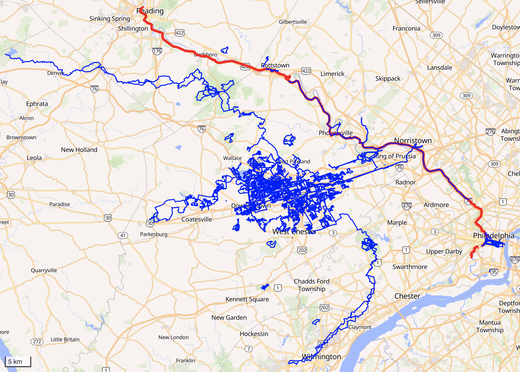
The Schuylkill River Trail (SRT) is another bike path. I had been doing parts of the SRT to connect down to Philadelphia, but nothing more. The SRT wasn’t a focus. Heck if I am being honest, even connecting to Philadelphia hasn’t been much of a focus. I just don’t feel like driving in that direction for a run that does not sound like it will be pretty.
However, as I am thinking about things to list here, I would say that is a likely candidate in terms of easier sidequests. At the very least connecting things to Philadelphia really should happen at some point. A good chunk of the river is also not that far from us, so it is a bit easier to get to. Furthermore, it will finally let me get around to connecting the heatmap from some races to the rest of my blob.
In case you read this and know Dutch: yes, Schuylkill is a Dutch word. I encourage you to pronounce it that way, even if the locals won’t understand you.
Other Side Quests: Enola Low Grade Trail, Conestoga Trail, Perkiomen Trail
As mentioned in the DC section, there is a trail called the Enola Low Grade Trail that I am hoping to connect to with my west pointing tendril. Another one I heard about is Conestoga Trail, which crosses the Enola Low Grade Trail, crosses Norman Wood Bridge (again, see the DC section), and also on its north end connects to the Horse Shoe Trail. Finally there is the Perkiomen Trail, which on the other side, branching off the Schuylkill River Trail and follows Perkiomen Creek.
Of these, I would say the Enola Low Grade Trail is the priority. Both for how it will look on the map and because it will, apparently, maybe make my connection to DC easier.
Once that one is complete and I have progressed enough along the Horse Shoe Trail, I feel like Conestoga Trail might connect things nicely together. I am not convinced about this one yet, it is more me taking notes of busy work further down the line.
Finally, I believe that the Perkiomen Trail is not very long. I just need to get in the mood to make progress on that. It does not connect me to anything I particularly care about and it will not look particularly nice on the map, so, ye.
Jotting Down Other Ideas
Suggestions welcome Stupid ideas encouraged.
- As briefly mentioned in the DC section, connecting to New York City would also be nice. I just have done nothing for that nor thought it out in any form.
- Connecting south east to Atlantic City (New Jersey) is something that I sometimes wonder about. I have some runs in NJ that I would connect on the way there and it seems like it would be a pretty straight line across NJ.
- I am not in any way used to camping or multiday walking. I do not have camping gear. Anyway, walking and camping a section of the Appalachian Trail sounds appealing. Maybe start with just a weekend?
- Once I have finished the Horse Shoe Trail, I might be tempted to connect it to Harrisburg anyway.
- Write my name somewhere that I am unlikely to run through in the future. Make it big enough that you cannot miss it when looking at my heatmap and having, say, both DC and Philadelphia in view. If feeling less egocentric: draw something. Perhaps somewhere along the DC-home route, I can draw an arrow pointing south-west and the text “DC”. Have that on the far end of Susquehanna. Have Philly on the near end.
- In Belgium, I had connected the Netherlands and France borders. Here in Pennsylvania, I found out there is a Holland, New Jersey right across the eastern border with New Jersey. There is also a Paris, Pennsylvania right before the western border with Ohio. The shortest route seems to be about 536 km and I never have to go west like that, so chances are pretty slim, but you know, adding it to the ideas box.
- Look at current map. Get to edge of heatmap. Run a vaguely circular route. Repeat. Use it to fill in the map with runs and making it look somewhat busy. Not sure how much I want this, but it came to mind while writing this post.
The end of this post feels a bit rushed again. I was getting tired of writing things out (planning them out is much more fun! actually running them even more so!) and wanted to just get it out there. Apologies for any mistakes.